The skies were clear as our turboprop flew to Napier. My brother & I could see as far as Mount Taranaki, more than 200km away! Also known as Mount Egmont, Taranaki is 2518m (8,261ft) above sea level, and is the natural centrepiece of the Taranaki region, located on the west coast of the North Island. I personally call this region the North Island's Ear because of its appearance from satellite photos. Napier is a port city in Hawke's Bay with a population of 58,100. Just 20km south lies the town of Hastings City with a population of 64,500. These two centres are often called 'The Twin Cities'.

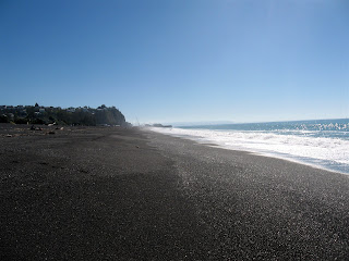
After 50 minutes, the plane landed safely in Napier and we disembarked onto the deserted tarmac. There are no baggage carousels at the Napier Terminal; instead your luggage is brought into a small garage by the airport crews & then you take them off the carts. The taxi ride into town was uneventful but my brother & I got to see a brief layout of certain streets. One thing that was clearly noticeable to me were the palm trees, conjuring up images of Los Angeles in my mind. The taxi dropped us off at the 4-star YHA hostel, and we checked into our twin room with ease. The hostel occupies a white cottage like house (that could use some inside/outside renovation) on Marine Parade Road along the rocky beach coastline. Marine Parade resembles Ocean Drive in Miami Beach except the street is lined with tall pine trees rather than palm trees.

Our stay in Napier would feel like 3 full days because we had arrived in the early morning & were checked in by 1030. With days to spare, I decided to walk around the area to see what the town has to offer. Along Marine Parade Road are restaurants, mini golf, skateboard park, children's park, Marine Land, and The National Aquarium of NZ. I should note that Marine Land has been closed since September 11th, 2008 because that's when Kelly, the last remaining dolphin, passed away.


Emerson Street is a road/street mall that runs through the centre of Napier. It's similar to the Sparks Street Mall in my hometown of Ottawa, Canada, except there're more shops than restaurants. On a positive note, there are cafes to for the hungry, but they're mostly situated next to Civic Square. Napier's 1930s Art Deco architecture has made it a popular tourist destination & has earned it the title of Art Deco Capital of the World. This style of architecture was introduced after the deadly earthquake on February 3rd, 1931. With the town centre & surrounding area destroyed, it was decided that the town would be rebuilt in the newest style at the time, the Art Deco style. The Art Deco Trust was established in 1985 to promote the city & maintain all the Art Deco buildings through donations. The Trust is located in the old fire station near Civic Square & offers guided walking/driving tours.


I proceeded to explore Napier South, getting a closer look to large cricket stadium we passed by during the taxi ride into town. The stadium is called McLean Park & was built in 1952. It's seating capacity is 22,000. Also nearby is the oval shaped Nelson Park. The park is basically a large green field surrounded by palm trees, and used to play community rugby & cricket. Kennedy Road is a main street that is lined with tall palm trees, occupying several parking spaces. Walking down this street with the clear blue sky above makes you think that you're in Los Angeles, California, but the left hand vehicle traffic reminds you where you're really are.
The afternoon sun forced me to retreat back to the hostel because I wasn't wearing a hat. Luckily, before my head really started to hurt, I bought some sunscreen at Pak n Save. The first day in Napier had gone by quite well. For the next day I would explore the Aquarium & the port.

To Be Continued . . .
(Post 7 of 10)

No comments:
Post a Comment